The Earth From Space: JT Reager
Curator Jay Belloli interviews JT Reager, Research Scientist, Surface Hydrology Group, Earth Sciences Section, NASA, JPL, Caltech.
Jay Belloli: How you become interested in studying hydrology and the earth's water cycle?
JT Reager: I was trained as an engineer, and I did aerospace engineering in the undergraduate program at Virginia Tech. I decided at some point that I didn’t want to work for a company that made weapons or had defense contracts or designed missiles or planes, or anything that one day could land on somebody and cause destruction. It was very hard finding an aerospace company that didn’t have defense contracts. It’s their bread and butter.
So I moved back home to Delaware and lived with my parents and did construction work for a year. I was looking for my next thing, and I found this program at the University of Delaware in oceanography, in ocean physics. You know the way the water moves around the planet in the ocean is not that different from the way the air moves in aerodynamics. A lot of the math and physics was similar for me. I took this oceanography program, it was wonderful, and I learned a lot. In the first month or so we went out on a boat to do our little research cruises. We would go around Delaware Bay and take samples and measurements of the water. I realized in the first few hours out there that I was a person who could get drastically seasick. I was struggling in all these cruises with ocean sickness.
I decided, okay, maybe this is not the career for me. I got my Masters, and I started looking for a PhD program in something else. I found this wonderful Doctoral program out here in California at U.C. Irvine in Earth Systems Science. In this PhD program, the students learned a little bit about all aspects of how the Earth functioned as a system. It was a great program with some superstar professors who each taught different aspects. I got very excited about the program. This was around the time that the first Al Gore movie came out, “An Inconvenient Truth”. I appreciated this movie, and I had this personal vision that I wanted to do something to help save the planet. You see a building on fire, you grab a bucket or a hose, you try to do something. And this my way to try and get involved and participate.
I worked with a professor there who was working with some satellite data from NASA to understand how water moves around the planet and how that was changing over time. We expect one of the strongest consequences of a changing climate on the planet is that there may be some reorganization around water - how water is distributed, where it rains and how much it rains, where it snows, how much it snows, and how that snow melts. In thinking about climate change, and constant increasing demand for water from population growth and expansion of agriculture, I saw some really interesting questions on the horizon about how much water we have, and how it will be distributed among the people who live here. And of course population and agricultural growth take water away from natural habitat and ecosystems.
By trying to answer these were very interesting questions, I felt I could make an impact on the world in my own little way. I got really excited about the UC Irvine program.
It sounded like an amazing opportunity, and I went for it. That’s how I started working with water.
JB: Tell me about the UC Center for Hydrological Modeling, where you did you Post Doc. Is that also at UC Irvine or is that somewhere else?
JTR: That’s right. The Center is at UC Irvine, but it is also a multi-campus center across the UC system. By bringing together colleagues from UC Berkeley, UC Davis, UC San Diego, the Center hoped to get a good picture of what was happening to water in the state. During my PhD and Post Doc, I started working with the GRACE mission, the Gravity Recovery and Climate Experiment, whose twin satellites were designed and commissioned at the Jet Propulsion Laboratory here in Pasadena. So pretty early on I started working with people at JPL. They have a history of working with satellites to study the water on the planet.
JB: So you wound up at JPL, which is one the most amazing places on the planet.
JTR: It is so cool. I love JPL. And of course there’s the whole reputation of NASA, which means there you are, walking around with that brand name on your CV. It’s a wonderful place to work, and a great platform to get science out to the public. I do a lot of public speaking and education. It’s part of what keeps me inspired. And JPL does things like the Mars Curiosity rover, which is believed to be the single greatest engineering achievement in the history of humankind. What we do, and the level of excellence at JPL, makes it very, very exciting.
JB: You’ve been at JPL about six years. Tell me about the research you've been doing there.
JTR: So at JPL we have three science sections: We have astronomy, which is things we are looking at in deep space, like exoplanets and dark matter; we have planetary science, which sends spacecraft to other planets in our solar system; and we have Earth science, which is the biggest science section at JPL. We have one hundred scientists in this section studying the Earth, and they are really the superstars of their profession. We have scientists that are studying ice sheets, or oceans, or forests, or the atmosphere, or water on land and how it is changing. We are really like doctors for the planet. Just like a doctor might listen to your heart with a stethoscope or take your temperature with a thermometer, we have all these instruments up in space and we are trying to interpret the vital signs of the planet and how they are changing. And we all have our different specialties, like a cardiologist or oncologist. It’s a great place to be. There’s always an exciting news release about something we just learned that we didn’t know before. We are working right there on the frontier of knowledge. Our day-to-day job is to try to ask questions about the Earth that nobody has answered yet. The more creative the questions and the more that we can add to understanding, this is what we are rewarded for in our work.
JB: Tell me about some of those questions.
JTR: Hydrology is based on the Greek words “hydros” which means water and “logos” which means study. We can now look across the planet and see how water in changing, and how it is affected by climate and human populations. Some things we’ve learned that we really didn’t understand before is that a lot of hydrology happens beneath the land’s surface. If we think about rain on a farm, a lot of that rain will sink below the surface soil, and at some depth will come in contact with the water table.
Water tables exist in some places beneath the Earth’s surface, and a lot of plants have the ability to grow their roots down and get access to that water – even if it’s dry at the surface or there’s a drought going on. The term used to describe this ability is drought resilience. Groundwater and the water table provide a lot of our drinking water, and a lot of water for pumping for agricultural use, especially in California’s Central Valley. A lot of that water is actually coming from the water table, particularly in drought years.
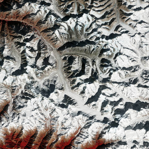
The ability to see this water below the surface has always been really challenging. You can dig a well here or a well there, but even if you aggregate all that well data together, you really don’t get a good picture of what is happening. The revolutionary thing that I have been working on is the two-satellite mission I described earlier called GRACE, Gravity Recovery and Climate Experiment. The first GRACE mission was launched in 2002, and was a joint effort with the German Aerospace Agency and the European Space Agency (ESA). Those satellites use changes in the gravity around the planet to actually understand changes in the amount of water stored beneath the land’s surface, without using any optical information or radar that hits the land and bounces back. As you probably know, the force of attraction between any two masses is gravity. On the planet if we have less mass, for example, when there’s not a lot of snow in the winter time on the Himalayas, so the gravity there is a little weaker. When the snow there is heavier, the gravity there is stronger.
The two GRACE mission satellites work in tandem. The satellites are watching each other constantly, monitoring the small moves each makes in its orbit. When there is more gravity at the surface of the Earth, each of the satellites gets pulled a little bit downward out of its orbit. They have GPS sensors on their roofs, which map the variations in each other’s orbit as they proceed around the planet. So with these satellites we can create monthly maps of what the gravity is anywhere on the planet. The only thing that is heavy enough and moves fast enough to change the gravity in a month or so is water. We can track month to month how water has moved. And with the GRACE records we can look at locations’ long-term patterns as well.
GRACE operated through 2017. And now we have a mission, GRACE FOLLOW-ON, which launched in 2018. We have this long record on places like California’s Central Valley, where over time we are seeing a constant decline in the gravity signal. That’s because we’re losing water from the Central Valley aquifer. We pump more and more water each year for agriculture. Especially during times of drought, we use more ground water than surface water. And that causes this rapid change.
JB: JT, if these GRACE satellites are going all over the planet, I assume you are getting information about subsurface water in a whole variety of places, including other countries. One of my questions is, what are you personally focusing on in terms of your research?
JTR: I’ve been involved in many studies over my short career. We’ve done a global study in which we focused on the thirty largest aquifers all over the planet. And we have seen how fast these are declining. We have found that about thirteen, or about half of them, are in some state of decline. We are using more water than is being recharged in these aquifers. And we found about eight aquifers or so that were in a really critical state of decline. Probably in fifty or so years, plus or minus a decade, we are going to get into trouble. Either those aquifer resources will be exhausted, or the quality of water, as you get to the bottom of the aquifer, will have so many dissolved solids and junk that they will not be clean or very useful for agriculture.
We see places around the world where the population is really booming: Northwest India; the South China plain, portions of the Middle East, and portions of the Central Valley here in California. The Los Angeles area is expected to have a population of fifty million by the year 2050 or so. It’s really scary. We’re already on the threshold here in L.A. of how much water is naturally available, and it’s not much. We are already piping it in from Northern California and the Colorado River. What are we going to do? If the population doubles, I'm not sure how we’re going to manage it. It’s a very important topic. It reaches beyond four-year election cycles, so no one really wants to talk about it.
JB: I’m listening to you talk about the subsurface water. What are some of the other large subsurface aquifers on the planet? Besides the California Central Valley, are there other large aquifers in the U.S., for example?
JTR: There is one other really large aquifer in the U.S. besides the Central Valley. You really need to understand that the Central Valley aquifer is huge. It provides water for about a quarter to a half of the produce in the U.S. We have nice weather year-round here. It’s possible to grow crops any time of the year here even without rain. You just need subsurface water to do so. The reason you can buy strawberries in Maine in February is because we grow them here. Agriculture in the Central Valley is a big industry, about twenty billion dollars a year.
The other major aquifer is in the central U.S. It’s called the High Plains aquifer. It’s in the southern high plains, and I think it reaches down into Texas and Oklahoma. This aquifer is also quickly depleting. We don't think it’s going to make it for another fifty to hundred years. It supports a lot of agriculture in the South-Central U.S. where they don’t get that much rain, but they have nice weather. They want to keep growing, and can do it year-round. Other major agriculture in states such as Indiana and the Eastern U.S. have enough precipitation there and enough natural irrigation to support agriculture.
If we think globally, there are six or seven major aquifers which are declining. One is called the North China Plain. The Chinese government has funded big agricultural to deal with rising population in big cities like Beijing. It’s a desert area of China, but they’ve tapped into this underground aquifer, and get this extra water to do agricultural production. There is another major aquifer in the Punjab province in Northwest India, overlapping with the Indus River, which is being used for agricultural expansion. The government is aware that the aquifer is being used for agriculture. But with the data we received from the GRACE satellites, we think the Indian government is underestimating how fast the ground water is declining. And, of course, there are national security implications with these shared aquifer systems, since part of it is in India and part in Pakistan, and these countries are enemies. With a number of these global aquifers, there are political and religious tensions. And if you add one more stress factor, such as a lot of people and not enough water, the situation could be unstable and potentially disastrous.
JB: I have another question. Since you are studying hydrology, I was wondering if you are also studying surface water as well as the changes in water in the atmosphere.
JTR: Yes, of course. Definitely. We deal with all these subjects. As hydrologists we want to have a complete understanding of the global water cycle. Changes in any one of these aspects will affect other aspects in the global water cycle. The big threat of climate change right now is snowpack. For example, whatever reservoirs we have built in California have a finite storage capacity, and can only hold so much water. But the Sierra Nevada snowpack could be about a hundred times the size of all of those reservoir systems. The snowpack is a natural reservoir system. Peak snowfall is about April first. So about April first the snow begins to melt through the spring and maybe it lasts through the summer. It provides this constant stream of runoff in the rivers that fills the reservoirs, and then is distributed for agricultural use.
What happens if we don't have snow pack in the Sierra Nevada, or it’s not cold enough to snow, or even if the snow starts melting earlier like in February instead of April? Well, then, we don’t have that constant supply of water that’s gently released through the summer. It shortens the growing season, and the agricultural production would be shortened as well. Again, if there is any change in a hydrological system anywhere, it will trickle-down and affect the system everywhere. It’s a complex system.
JB: I know if snow loss happens in the Himalayas, it affects the entire situation in India a lot, especially since it is one of the two most populous countries on the planet. And that could be disastrous, because it is a system similar to the Sierras. I’m trying to think if other major systems like the Alps, have similar circumstances in terms of snow loss because of climate change.
JTR: It’s global for sure. And the major mountain systems, where there are glaciers like in the Alps or the Andes or the Himalayas, they are dealing with the same issues of less snow and ice on these mountains, and less runoff as a consequence. In Asia they refer to the Himalayas as the Asian water towers. They provide water for so many countries, from China, down the Mekong River through Southeast Asia, and also central India and Pakistan. Even a reduction of ten or twenty per cent in the amount of water provided by these mountains could have serious consequences that are really worth planning for.
JB: Partly from talking to oceanographer Josh Willis, one of the things that I am aware of is the whole situation created by a warming planet. As the atmosphere warms, it can contain far more water vapor, which leads to increased rain events on land. I know how that can affect floods. But I don’t know what it does in terms of potential subsurface water. I lived in Houston for a while, and Houston has just ramped up incredibly in terms of major rain events. Are major rain events impacting subsurface water as well? Or do these rain events happen so quickly that the water just runs off and doesn’t have a chance to be absorbed down to the water table?
JTR: Your question makes sense. Maybe Josh Willis mentioned (Josh is a great guy, by the way) that there is something we call the acceleration of the water cycle, or the amplification of the water cycle. This is exactly what you propose. With climate change there are more extremes in the water cycle. So there are more droughts and more floods in general. The actual mechanism is something that we call the rich get richer mechanism. What it means is that, for places that are already pretty wet, there is going to be more atmosphere capacity. Whatever mechanism is already delivering water to those places probably will be able to deliver more water to those places. The atmosphere can transport more water laterally from the ocean or from wherever and it dump more water in those places.
So the wet places are getting wetter, and the dry places are getting drier. The dry places are usually hot and not enough water is delivered to those places. If with climate change they are going to get hotter, they are probably going to get even drier. In the hydrology cycle, this is what is expected with climate change. And exactly as you suggested, in places that are now prone to occasional floods, the rain will be more frequent and more intense, and more of the rain will end up as runoff. And therefore less of the rain will penetrate the land surface.
In Texas you know this type of cycle happens all the time. You get a lot of months that are really dry. The ground gets so dry and hard that even when it rains, that rain can’t infiltrate the soil. It’s just like hitting pavement. This causes big floods. You therefore get more of these combined drought and flood events. The rain is too fast and it runs off too quickly so it doesn’t benefit the ecosystem.
In places where ground water used, like California’s Central Valley or the Southern Plains aquifer, more drought means more ground water consumption if we want to maintain the same level of agricultural production. Agriculture uses about eighty per cent of the water around the planet. Residential use is about ten to fifteen percent and industrial use is about five to ten percent. Agriculture is the big driver. As the international population grows and we have more and more people, we will use more and more water. Water use is also impacted by what you are growing. For instance, a pound of beef has embedded in it about 1600 gallons of water. You need to grow all the feed, and you need to feed the cow for about one year, which is a typical harvesting age for cattle. So the amount of embedded water in the actual pound of beef you are eating is really incredible.
There is a virtual water train as well. That’s how water moves around the planet in agriculture. We are probably looking at a future where we will have to alter some of our agricultural practices, move towards more efficient agriculture. We will have to consider really what the best use of our water is as a shared resource, especially because of population growth, areas getting drier, and less frequent rain events.
JB: There are types of agriculture that don't use water as extensively because of the intelligent use of the land. If you plow, you have water that evaporates from the soil. There is a more efficient growing situation where you just turn the soil in the rows. I know this approach is not widespread, but there are some farmers who are doing it the Midwest.
JTR: I am a convicted optimist. I am so convinced that we can deal with all of these issues, with technological solutions, and with policy solutions. There are so many solutions to climate change climate and ways to adapt to climate change. The solutions are there.. The thing to worry about is all the political resistance to making these changes. It’s] the only issue that is our way - not technology or our ability to adapt. As you said, there is drip irrigation. In the Central Valley, drip irrigation is a great idea, super-efficient. It’s a little expensive to install. But most farmers will reap the rewards from the water saving, especially as water prices might go up in the future.
However, certain crops in the Central Valley sell very well, like almonds, but are complex from a water standpoint. The Central Valley grows about ninety per cent of the nation’s fruits and nuts. One of the central drivers for consumption right now is almond milk. People who are vegan or want a milk alternative are buying almond milk, which is driving up the demand for almonds in the Central Valley. The famers want to make money and do a good job growing almonds. The trouble with almonds is that they grow on trees, which need to be watered year-round. And typically they are watered by flood irrigation. They flood the entire field with water, and let that water sit there. That’s how almonds like to grow. But about eighty percent of that water just evaporates into the air. This is just such a complicated situation. You could not grow almonds, but there is demand for almonds. The human solution to this is that, as consumers, we really buy our reality. We need fair pricing. Consumers at the grocery store should pay the actual price for that almond milk, which takes into account the true value of that water - the water that is a finite and shared resource for all of California. A gallon of almond milk could be very expensive.
JB: I have a question. There is all this water in the aquifer that is being brought up for use. Some evaporates. Does some go into the normal water system such as rivers, lakes, and ultimately the ocean? I certainly understand the issue of ice melt, because I talked to Josh Willis about that, and how that is affecting sea level rise – as well as the oceans getting warmer and expanding because of the heat. But is there any impact from subsurface water getting into the water system and raising the sea level?
JTR: That’s a good question. There are two answers, both a global consequence and a local consequence. We are pumping all this ground water and using it right there. We water our crops, and our fields. Some of the water makes it into the actual crops. But most of the plants transpire the water through their leaves. That’s how healthy plants function. They release water to be able to absorb carbon dioxide from the atmosphere. So a lot of that water vapor ends up in the atmosphere, and possibly gets carried back over the ocean. Or if the water finds its way into streams and rivers, and does get carried into the ocean.
Human produced groundwater depletion has become a major component in global sea level rise. Three big things contribute to sea level rise right now. First, the oceans are getting warmer and expanding. Second, Greenland and Antarctica are melting. And third, glaciers, like in the Himalayas or the Alps are melting and that water is going into the ocean. However, by about the year 2035 or 2040, scientists estimate that human produced groundwater depletion will overtake melting glaciers as the third most important component in sea level rise. It’s just because mountain glaciers are getting smaller. Pretty soon they are pretty much going to disappear. But groundwater depletion is ongoing. In the aquifers we have about 50 or 60 years of water left at the current rate, I’m assuming, until it actually gone.
Now that’s the global effect for groundwater depletion. There is also a local effect in many places. In California a lot of the soil that constitutes the aquifer is called Corcoran clay. When you look at a little mineral of clay, it looks like a coin; it’s flat and round. When this clay is submerged in water, they tend to stack on top of each other in a random pattern - some are upright, some are on their side, and some are diagonal. They are in a kind of matrix structure, and they support each other. When you pump the water out and put some weight at the surface from, say, normal human activity, these clay materials collapse. And that small space between them is lost.
This activity at the surface is called subsidence. In the California Central Valley subsidence has been happening for about a hundred years or so. And we’ve lost about 230 feet of height. When we were in the worst of the drought conditions in 2014 and 2015, portions of the Central Valley that were sinking at a rate of one foot per year. During this time, Governor Brown was talking about building a high-speed railway that would reach from San Diego all the way to Sacramento and San Francisco. You have this 19-billion-dollar high-speed rail project going up the Central Valley. And you don’t know that, when you are pumping groundwater, the land is sinking and shifting and moving all around, causing major risk to infrastructure.
Subsidence is an effect that is happening in connection with many of the world’s aquifers. It’s causing problems with homes, levees, water transport and other infrastructure like roads and highways. It’s something that the State of California is taking a very serious interest in. Governor Brown in 2014 issued the Sustainable Groundwater Management Act, or SGMA, including a special clause urging that something be done about subsidence, especially to understand where it is happening and how much it is happening. And that local water agencies need to have a plan in place by the year 2022 or so - to try to mitigate subsidence. It’s a major issue for sure.
JB: Has anything happened with the planning, besides the legislation?
JTR: You can read about SGMA online. It is for local water agencies to decide how best to achieve the standards in the legislation. The State government doesn’t actually do anything. The State said, “Hey, you better get your act together by 2022. Otherwise you’re not going to get any more State funding,” or something like that. So a lot of the little water management agencies around the Central Valley and elsewhere are hiring consultants. The agencies don’t even know how much water they are actually pumping. They don’t keep track of how many wells are on farms. And they don't know how much subsidence is happening in various places. They are trying to measure and monitor it first, and then come up with plans to mitigate it. There probably is a safe and sustainable amount of groundwater use in every place. But we’ve always far exceeded that for many years.
At NASA we have several projects with the DWR, the California Department of Water Resources. We are working with a local agency like the USGS (United States Geological Survey) to monitor the water resources and to do some computer modeling to find out where the worst places are. How much water do we actually need to stop pumping to get things in balance? So there is a lot of activity about water right now.
JB: There is something that you worked on which you haven’t yet talked about. That is extreme hydrological events. What are those? Have we talked about them already but not named them that way?
JTR: That’s really fancy terminology for floods and droughts, which we’ve been able to monitor a lot with the GRACE satellites. Let’s say you have a drought in California. During that drought everything is getting drier. People are using more groundwater. But you don’t really have information about how the water under the surface is changing. But with GRACE we have this new monitoring capability to really measure how much water is missing from the system at any given time during the drought. With that number we can actually say how much it will need to rain to get out of the drought. So we can say when the drought started, when it was over, and how much water was missing during the drought.
JB: That’s incredibly helpful.
JTR: We’ve done a little bit of work on the flood side as well. There were really big floods in the Mississippi River basin in 2011 and 2019. When they have huge floods in that basin, it’s not just because it is raining. It may be because snow melt has saturated the soil. So just like a bucket, there’s only so much water you can add until the bucket spills over. With the GRACE satellites we can look at the whole Mississippi River basin to see how wet the basin is, and how much space we have until it starts to run over. That gives us the ability to predict floods just a little earlier than if we were just looking at weather forecasts. Weather forecasts are only good three to ten days in advance. But we can track the wetness in the basin for months in the spring to see how wet it’s getting.
JB: One of the things I know you were interested in is the hydrology related to fire seasons. As you know, in California it’s gotten worse and worse over the years. Are the increased temperatures, which tend to dry thigs out, the hydrology issue? Or is it something else?
JTR: That’s a really good question. We found out, with our study of hydrology and fire, that in most places in the country and the world it is pretty simple. You have a forest or something else that can burn. The drier it gets the worse fire season you will have. But in places like California, we tend to get our water in something like a monsoon season in the winter. So we tend to get fires during the summer and the fall. But when we have a wet winter, there tend to be more grasses, chaparral, and shrubs. They start growing like crazy, and the end of the summer they dry out. So then we have a big fire year – even though it’s counter-intuitive. A few other places in the country are similar.
JB : You’ve learned a lot since your study at U.C. Irvine. You’re an activist, which I was glad to hear. What future changes may happen in terms of hydrology? Obviously it has to do with changes in behavior and changes in policy. You’re an optimist. So what changes are we in for?
JTR: We talked about climate change, and wet places getting wetter and dry places getting drier. Certainly the decline in water resources is something to worry about. And population growth, warming temperatures, and less snowpack are things coming in the future. When we sit around as Earth scientists at JPL – we all have our different specialties – we are all talking about the future. Josh [Willis] is talking about ice loss, I’m talking about the loss of groundwater, someone else is talking about the Amazon fires, and we all come to the same conclusion.
We somehow have to get people to care about this. Stimulate people to understand that it’s in their best interest in order to live a great, happy life. Don’t restrict yourselves, but also just consider the planet. We can come up with solutions together. It is that kind of optimism that we really need. Just be aware. Whenever I give a lecture out in public I say, “You don’t have to do anything. You can drive a car. I drive a car. I fly in planes. Don't worry so much. Just make it part of your consciousness. Have one conversation a day with a friend about climate change or water resources. Just made a part of your everyday activity and your consciousness.” And I think the rest will take care of itself. There is standard answer I always give. Eat less meat, eat less beef. That seems to have a variety of consequences, from Amazon forest fires to water consumption to climate change and increased carbon dioxide. That’s the recommendation I throw out there. But there isn’t just one simple solution. There are a million solutions out there. We have more solutions that we need. We just need people to care a little bit more. Even ten percent more, and it would make a big difference.
JB: JT, I enjoyed this interview a lot. Thank you so much for your time and also for your expertise.
Of the 30 largest groundwater aquifers on our great planet Earth, we have found that about half of them are in some state of unsustainable decline. Probably, in 50 or so years, we are going to start seeing a critical exhaustion of these precious water resources.
JT Reager Research Scientist, Surface Hydrology Group, Earth Sciences Section, NASA, JPL, Caltech
The Earth From Space
A new virtual exhibition
ArtCenter Exhibitions Presents
View artist video works, talks and panels from current and past exhibitions.